Since 2008 the sew systems gmbh is increasingly focusing on Geo-Services, meaning IT-Services, in which the geographical context plays an important role for the service itself. As a consequence logistic processes and challenges moved closer into the focus of the sew systems gmbh. Not only research-related projects were jointly or by order of the Johannes Kepler University carried out, but also projects with commercial partners such as the Upper Austrian traffic network, the Linz Linien GmbH or Hödlmayr Logistics Austria in Schwertberg. Some of these project are mentioned here after.
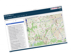 ITCS Load Tester & Simulator - The ITCS Load Tester simulates the behavior of ITCS clients in public transport in Upper Austria and thus provides the opportunity to check the performance of the ITCS system (PUBLIQ.operation), a software developed by GEVAS. On one hand the ITCS Load Tester allows load testing, visualizing and statistically analyzing an arbitrary number of simulated clients on arbitrarily definable traffic routes of public transport in Upper Austria, and on the other it enables to simulate selected target routes in real time. In order to provide reference data for real time comparison with data from the real vehicles the simulation component also allows to simulate all vehicles currently used in public transport in Upper Austria.
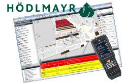 HODG - is a tool for optimizing and visualizing the logic processes on the factory premises of the Hödlmayr Logistics Austria in Schwertberg. Vehicle movements are optimized in terms of labor, time and moving distance and the current stock status as well as the position and the history of every single vehicle is visualized in a master control application.
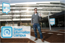 JKU Smart Information Campus - The Smart Information Campus (SIC) is an information system for students and members of the JKU Linz. It is available for iOS and Android as well as Symbian, Windows (PC) or as a web application. SIC helps to orient on campus or find POIs nearby and allows to connect with friends on a map and to chat with them. In addition, SIC provides access to infrastructure facilities such as the tram Monitor, the cafeteria or the event and LVA calendar at the JKU.
Rights Disclaimer
All projects listed above were implemented either completely, partly or with the participation of either the sew systems gmbh, formerly Software Engineering Weichselbaum, or of Otto Weichselbaum ad personam, either as a contractor, sub-contractor or as an employee and are merely illustrative of the know-how at sew systems gmbh.